Air Quality Data Directory

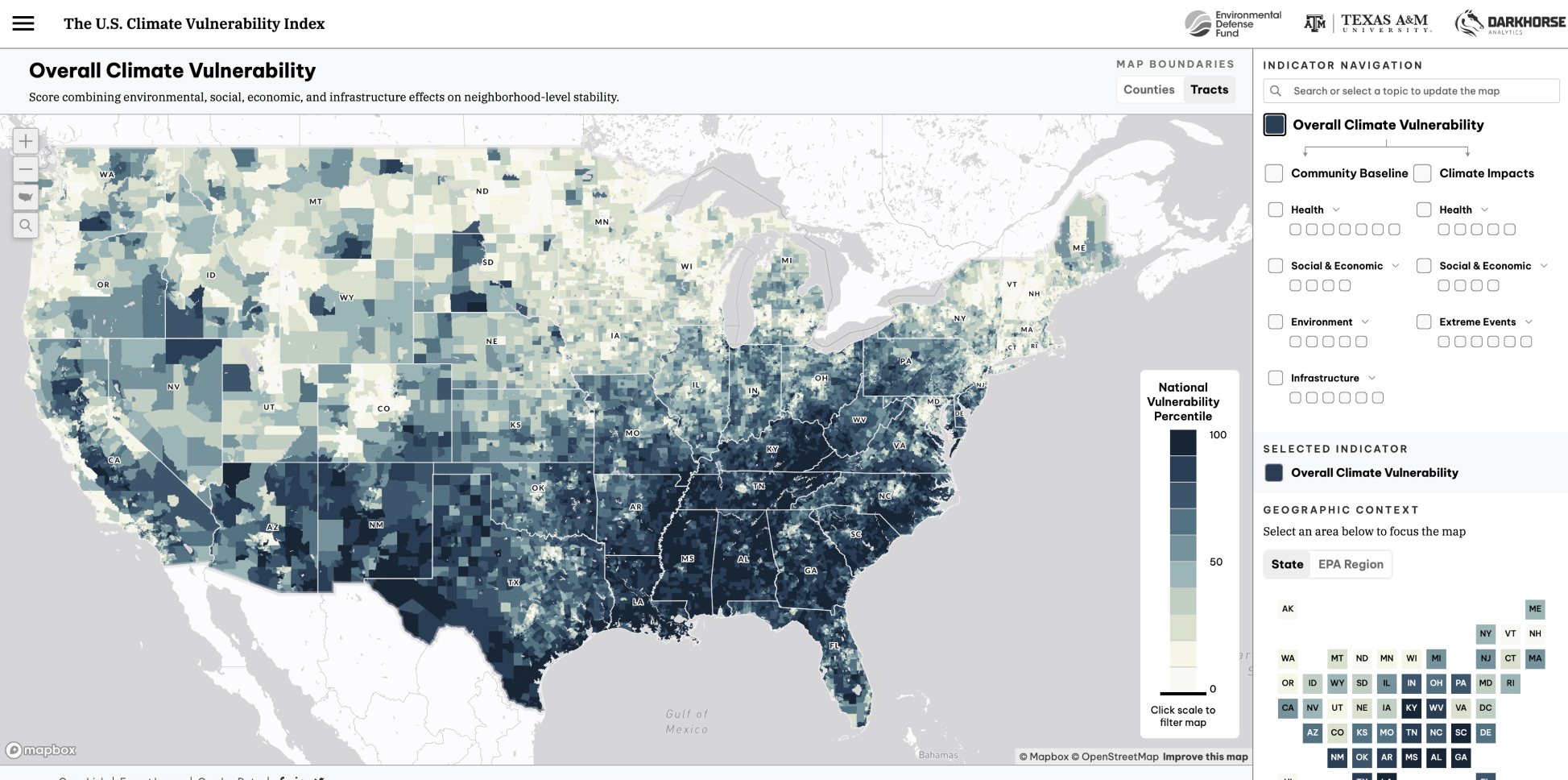
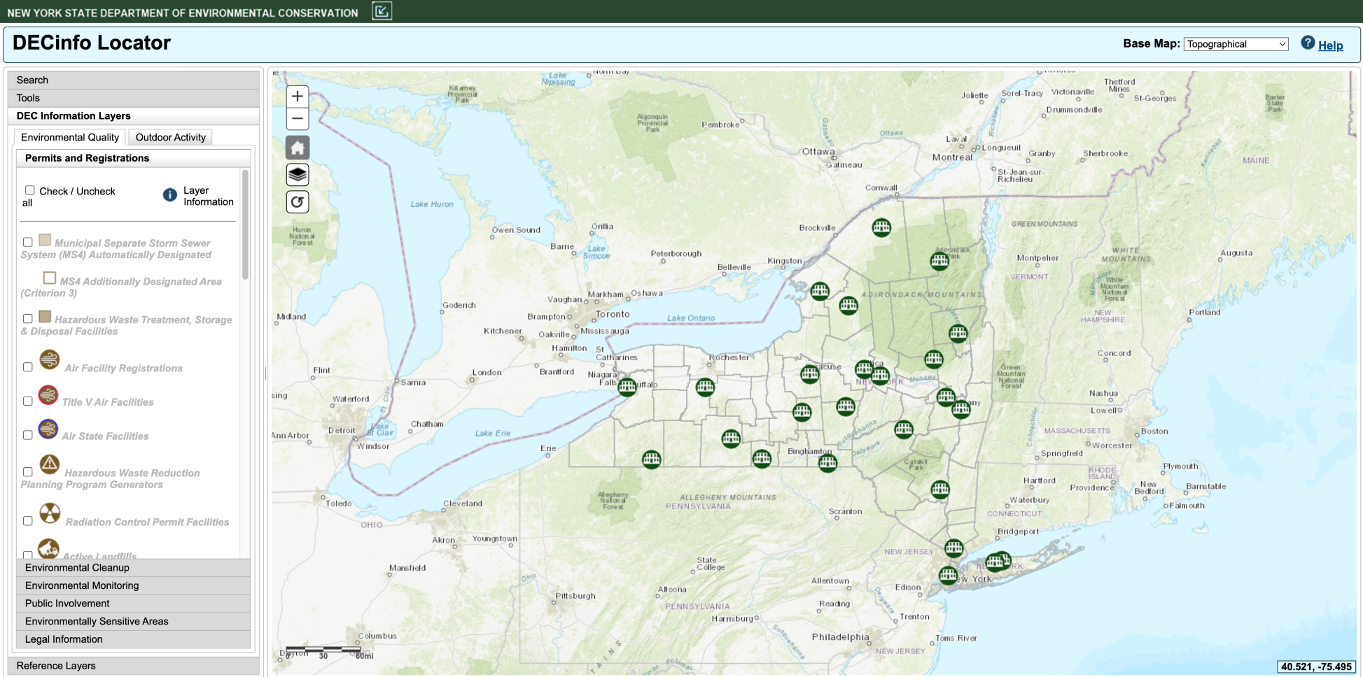
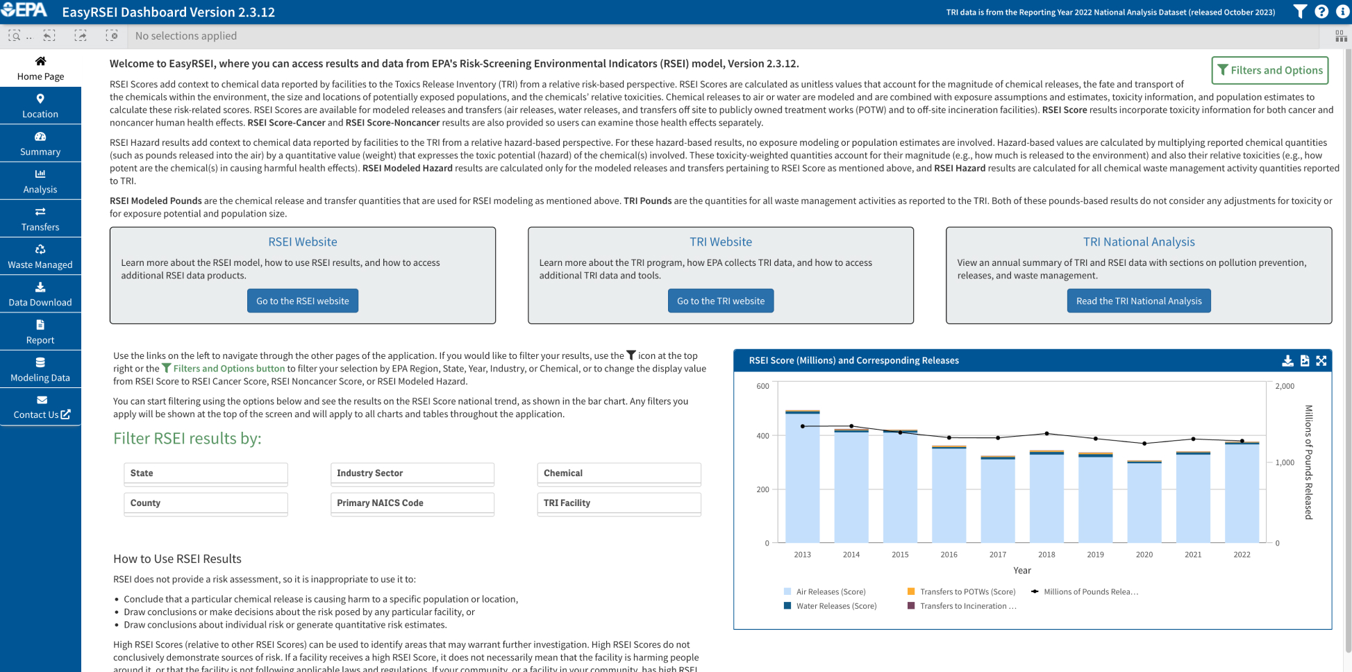
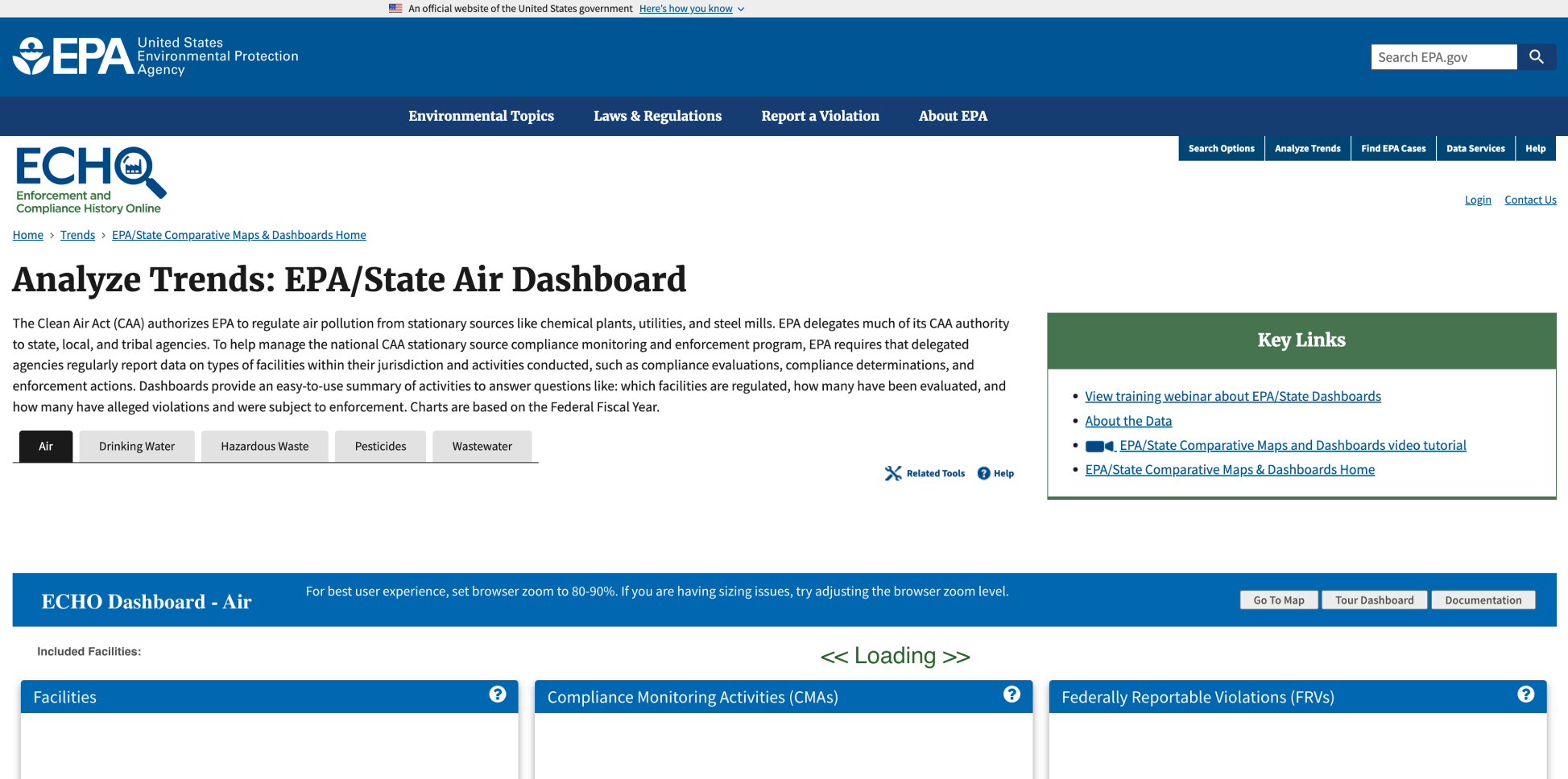
Knowing how to find and use relevant air quality data has proven to be a challenging barrier for data-informed legal action and clean air advocacy. To help address this challenge, EDF has created a central directory of both air pollutant emissions databases and associated tools.

This searchable, filterable database allows users to learn more about each database and tool. EDF developed this inventory in collaboration with partners and clean air advocates, prioritizing databases and tools that are the most user-friendly and relevant for advocacy. 

Would you like to see a specific resource added to our directory? Please fill out this form or email us.

Filters
Tool or Dataset?
Category of Data
Category of Data
Types of Pollutants
Type of Pollutant
Spatial Extent
Spatial Extent
Provider
Provider
Potential Uses
Potential Uses
Temporal Resolution
Temporal Resolution
Update Frequency
Update Frequency
Air Emissions Inventories
Compilation of air emissions inventories by state.

Dataset

Air Toxics Screening Assessment (AirToxScreen)
Ongoing review of modeled air toxics concentrations and risk estimates for possible associated health impacts in the U.S. (cancer and non-cancer).
AirNow
AirNow
Interactive map of air quality that includes data for air quality monitors in the U.S., Canada, and Mexico.
AirToxScreen Mapping Tool
Visualization of AirToxScreen results in a map format.
AirTracker
AirTracker
Mapping tool to visualize connections between the air residents are breathing and the locations of sources of air pollution throughout a community.
American Community Survey Gini Index of Income Inequality
Map of income inequality, using the Gini index-- an economic and statistical dispersion model that measures income inequality
Atlas Wetlands Impact Tracker
Tracker that follows the development of federal permitting under the U.S. Army Corps of Engineers.

Dataset

California Air Resources Board AQMIS Air Quality Data
Query tool for California air quality data, filterable by pollutant.
California Air Resources Board Pollution Mapping Tool
Filterable map of pollution by facility in California.
CAMP Air Quality Dashboard
Spatial visualization of sensor data for particulate matter and VOCs in Harris County.
Carbon Majors Database
Database of historical production data from 122 of the world’s largest oil, gas, coal and cement producers. Used to quantify and attribute the direct operational emissions and emissions from the combustion of marketed products.
Carbon Mapper Data Explorer
Interactive map to visualize where, when and how methane and CO2 emissions are released.

Dataset

Centers for Disease Control (CDC) PLACES
Provides health data for small areas across the country. PLACES includes model-based, population-level analysis and community estimates of various health measures to all counties, places (incorporated and census designated places), census tracts and ZIP Code Tabulation Areas (ZCTAs) across the U.S.
Chemical Action Map
Chemical Action Map
Maps sources of highly toxic chemicals and identifies associated health risks (asthma, cancer, developmental harm).
Chemical Incident Tracker
Database and map to track most recent hazardous chemical disaters from news reports.
Clarity Dashboard
Clarity Dashboard
Visualization of real-time hyperlocal measurements of air quality collected by Clarity monitors.
Climate and Economic Justice Screening Tool
Interactive map featuring indicators of burden to identify disadvantaged communities. The categories of burden include climate change, energy, health, housing, legacy pollution, transportation, water and wastewater and workforce development.
Climate Trace Map
Climate Trace Map
Map to visualize global emissions inventories, including functionality to compare countries and filter by emissions sources.
Climate Vulnerability Index
Uses 184 sets of data to rank a community's vulnerability to climate change. Considers four baseline vulnerability categories (health, social/economic, infrastructure, environment) as well as current and projected impacts of climate change.
Coastal Use Wetlands Tracker
Tracker for current and proposed carbon waste projects in Louisiana.
DECinfo Locator
DECinfo Locator
Provides access to New York Department of Environment Conservation documents and public data about the environmental quality of specific sites in New York.
EasyRSEI
EasyRSEI
Filter by specific facilities, locations, chemicals and years related to toxic emissions and create custom charts, maps and tables.
ECHO Dashboard
ECHO Dashboard
Search engine and dashboard to explore facility compliance with environmental regulations.
EJNYC Mapping Tool
EJNYC Mapping Tool
Interactive map to visualize various indicators relavant to environmental justice concerns of New York City.
EJScreen
EJScreen
EPA's environmental justice mapping and screening tool using a nationally consistent dataset.

Dataset

Enforcement and Compliance History Online (ECHO)
Enforcement and compliance data for air emissions from stationary sources, surface water dischagers, hazordous waste handlers and drinking water systems. Includes permit data, inspection/compliance evaluation dates, violations, enforcement actions and penalties assessed.
Envirofacts Toxic Release Inventory Search
Basic facility-level information for any facility that has reported Toxic Release Inventory data since 1987.

Dataset

Environmental Protection Agency (EPA) Air Toxics Data Ambient Monitoring Archive
National monitoring data for air toxics measurements for most states, specifically Hazardous Air Pllutants (HAPs). Chemical concentrations/measurements pulled from ground-based monitoring.

Dataset

Environmental Protection Agency Air Quality System (AQS) Data
Ambient air pollution data collected by EPA, state, local and tribal air pollution control agencies from thousands of monitors measuring chemical concentrations and meteological data.
Environmental Protection Agency AirData Air Quality Monitors
Provides air quality data from outdoor monitors across the U.S. and includes interactive map visualizing locations of air quality monitors.

Dataset

Environmental Protection Agency National Emission Inventory (NEI)
Compilation of air emissions estimates from various sources, including point sources like petrochemical facilities, transportation and fires. Data is compiled from other EPA emissions programs and from data provided by state, local and tribal agencies.

Dataset

EPA records for benzene levels monitored at refinery fencelines
Data on refinery benzene emissions from fenceline monitoring.
Existing and Proposed CO2 Pipelines in the US
Maps known and available routes of existing and proposed CO2 pipelines in the U.S. and generates demographic and community-level information, incorporating data from EPA's Environmental Justice Screening Tool and the Climate and Economic Justice Screening Tool. 
Facility Level Information on GreenHouse gases Tool (FLIGHT)
Visualization of greenhouse gas (GHG) emissions from large facilities in the U.S as maps, tables, charts and graphs for individual facilities or groups of facilities
FencelineData.org
FencelineData.org
Database that includes information on facilities' chemical emissions rates and compliance history. Users are able to search by facility, location, and chemical substance
Follow the Oil Ownership Tracker
Map of oil and gas infrastructure in Louisiana by company.
GeoTAM dashboard and viewer
Map of air monitoring sites in Texas. Includes associated emissions data.
Global Energy Monitor
Compilation of tracker maps and projects providing open access data on various energy sectors.

Dataset

Greenhouse Gas Reporting Program
Reported emissions from large GHG emission sources, fuel and industrial gas suppliers, and CO2 injection sites in the United States

Dataset

Gregory-Portland Air Quality Program
Continuous air monitoring program that measures ambient (outdoor) air quality and chemical compounds in Gregory-Portland, Texas.

Dataset

Harris County Community Air Monitoring Program (CAMP)
Data from sensors that measure pollution levels in chemical concentrations across Harris County
Harris County Mobile Air Monitoring
Map visualization of air quality monitoring data in Harris County.
Institute for Health Metrics and Evaluation Data Tools
Research and analysis organization offering various tools to visualize global burden of disease and exposure.
Lone Star Legal Aid Community Pollution Reporting Tool
Reporting tool for residents across 72 counties in the Eastern and Gulf Coast regions of Texas to report various types of pollution like odors, releases, water pollution, air pollutants and noise from facilities in their neighborhoods.
Louisiana Cancer Data Visualization
Multiple visualizations for cancer incidence in Louisiana from 2015-2019.
Louisiana Cancer Maps
Interactive mapping visualization of cancer data for 71 cancer reporting zones in Louisiana. Maps cancer incidence for the 20 most common invasive cancer sites and filter by sex and race/ethnicity.

Dataset

Louisiana Department of Environmental Quality (LDEQ) ERIC
Louisiana public reports of estimated emissions per pollutant, by parish or radius.
Louisiana Department of Environmental Quality Air Monitoring Sites Map
Map of air monitoring sites throughout Louisiana. Includes associated monitoring data.

Dataset

Louisiana Tumor Registry
Data on the incidence of cancer and cancer-related deaths in Louisiana. This information includes the types of cancer, anatomic location, stage at diagnosis, treatment and outcomes.

Dataset

Lousiana Department of Environmental Quality (LDEQ) VOC Canister and PAH Sample Data
Data generator that pulls chemical concentrations from 16 ground monitoring sites (2 Photochemical Assessment Monitoring Stations, 14 Special Purpose Monitoring Stations). Can be filtered by site, parish and temporal resolution.
LSU Health Risk Factor Dashboard
Identify and learn more about cancers associated with various risk factors in LA. Users can toggle between different cancers associated with various risk factors (i.e tobacco use, obesity etc.), and see statistics on each
Monitoring for Benzene at Refinery Fencelines
Report on benzene monitoring at refinery facilities from 2018-2023.
National Emissions Index 2020 Report Exploration Tool
Dashboard that allows user to explore the 2020 National Emissions Inventory report data.

Dataset

National Health and Nutrition Examination Survey (NHANES)
Program of studies designed to assess the health and nutritional status of adults and children in the U.S. Combines demographic, health behavior and chemical measurements in health samples.
National Health and Nutrition Examination Survey Dashboard
Visualization of survey data on chronic disease, diet etc. across decades
Neighborhood Witness Emissions Database
Emissions database with information on Texas facilities' emissions events, high-concern contaminants and pounds of pollution released.
Oil and Gas Watch
Oil and Gas Watch
Interactive map and database with locations of proposed, new and expanding oil, gas and petrochemical infrastructure projects that have been approved or announced since 2012.
Oil Climate Index (plus gas)
Visualizes how various oil and gas products that are made have varying effects on GHG emissions
Screenshot (48)
OpenAQ
Open-source, open-access global database of real-time and historical air quality data, harmonized for ease of use and accessible via an API or via OpenAQ Explorer, a map-based interface showing real-time data and related visualizations.

Dataset

Pennsylvania Department of Environmental Protection (PDEP) Air Emissions Report
Public access air quality database for Pennsylvania.
PLACES Interactive Maps
Interactive maps for model-based estimates of 36 chronic disease related measures at county, place, census tract and zip code levels.
ProPublica Map
ProPublica Map
Map visualizing cancer risks associated with emissions from industrial facilities.
Purple Air
Purple Air
Visualization of real-time hyperlocal measurements of air quality collected by Purple Air monitors.
QuickFacts
QuickFacts
Search by location and find estimated quick stats about the U.S. population.

Dataset

Refinery Capacity and Utilization
Includes information on the industrial capacity of petroleum and other liquids per refinery facility.

Dataset

Refinery Capacity Report Archives
Archival data series including fuel, electricity and steam purchased for consumption at refineries; refinery receipts of crude oil by method of transportation; current and projected atmospheric crude oil distillation; and downstream charge capacities and production capacity of selected products.
Response Outreach Area Mapper
Identifies hard-to-survey areas and provides a socioeconomic and demographic characteristic profile of these areas.

Dataset

Risk-Screening Environmental Indicators (RSEI) Model Output
Uses Toxic Release Inventory data to provide estimates on the amount of toxic chemicals released or transferred from facilities, together with factors such as the chemical’s fate and transport through the environment, each chemical’s relative toxicity and potential human exposure. Explore data for chemicals, industry sectors, facilities and geographic areas with the greatest potential for chronic human health impacts. Includes modeled chemical concentrations, toxicity-weighted concentrations and RSEI Scores.
Spill Tracker
Spill Tracker
Running list of petrochemical industry disasters across the U.S.

Dataset

Texas Air Emission Event Report Database (via STEERS)
Reports of excess/upset emissions in Texas. Data includes emissions ocurring during periods of startup, shutdown, malfunction and maintenance events.

Dataset

Texas Commission on Environmental Quality (TCEQ) Automated Gas Chromatograph (AutoGC) and Canister Monitoring
Chemical concentrations from Texas Commission of Environmental Quality AutoGC monitoring stations. Filterable by parameters or by site.

Dataset

Toxic Release Inventory (TRI)
Tracks the management of certain toxic chemicals that may pose a threat to human health and the environment. Data includes facility name, chemical ID and quantities of chemicals released, transferred and managed.
Toxic Release Inventory Explorer
Search by chemical, location, industry sector, or tribal land to produce a report of TRI emissions.
Toxic Release Inventory Toxics Tracker
Searchable database for Toxic Release Inventory facilities. Search by address or facility name and view summary-level TRI data for the latest reporting year.

Dataset

U.S. American Community Survey
Annual demographics survey data intended to help understand changes taking place across communities.

Dataset

U.S. Census
U.S. Census
Data from collection of demographic surveys conducted every 10 years.
U.S. Oil Refinery Fenceline Monitoring Data
Includes data for emissions at oil refineries, how often pollutant is measured, refinery performance and associated data.
US Energy Information Administration Petroleum Refineries
Detailed map of petroleum refineries across the U.S.
World AQI
World AQI
Real-time Air Quality Index visualization for countries across the world.